- Retrait gratuit dans votre magasin Club
- 7.000.000 titres dans notre catalogue
- Payer en toute sécurité
- Toujours un magasin près de chez vous
- Retrait gratuit dans votre magasin Club
- 7.000.000 titres dans notre catalogue
- Payer en toute sécurité
- Toujours un magasin près de chez vous


Description
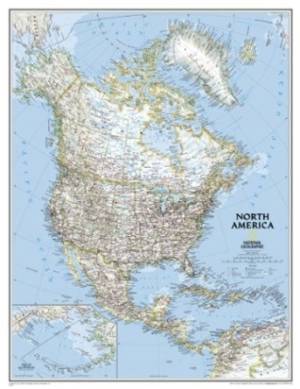
From the far northern reaches of the Arctic Sea to the Isthmus of Panama, this Classic style political map of North America features trademark National Geographic detail and accuracy. The bright color palette features blue oceans and stunning shaded relief that has been a signature of National Geographic wall maps for over 75 years. Political boundaries are clearly defined, and place names, airports, major roadways, and other geographical features are easy to read. In addition to Canada, the United States, Mexico, and Central America, coverage includes Iceland, Greenland, the island nations of the Caribbean, Venezuela, and most of Colombia. An inset map shows the Aleutian Islands off the coast of Alaska.
The map is packaged in a two inch diameter tube with a label showing a thumbnail of the map with dimensions and other pertinent information.
- Map Scale = 1:14,009,000
- Sheet Size = 23.5" x 30.25"
Spécifications
Parties prenantes
- Auteur(s) :
- Editeur:
Contenu
- Nombre de pages :
- 1
- Langue:
- Anglais
- Collection :
Caractéristiques
- EAN:
- 9780792281016
- Date de parution :
- 24-08-17
- Format:
- Carte roulée
- Dimensions :
- 60 cm x 77 cm
- Poids :
- 55 g