
- Retrait gratuit dans votre magasin Club
- 7.000.000 titres dans notre catalogue
- Payer en toute sécurité
- Toujours un magasin près de chez vous
- Retrait gratuit dans votre magasin Club
- 7.000.0000 titres dans notre catalogue
- Payer en toute sécurité
- Toujours un magasin près de chez vous


Description
Since the Middle Ages maps not only served to navigate and to depict the world as it was then known, they also document the progress of humanity in exploring and understanding the world in which we live.
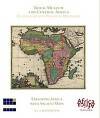
With this publication the Royal Museum for Central Africa presents a selection of 80 maps of Africa and its parts from its collection, dating from the late 15th to the early 20th century. Beginning with maps originally defined in Alexandria by the Greek geographer Ptolemy in the 2nd century AD, they reflect the results of early Portuguese explorations, gradually improving the shape of the continent. Mythical creatures and beasts populate the unknown interior, giving rise to creative embellishments, until scientific explorations in the early 19th century replace fables by facts.
As the small format of the publications in this series cannot do justice to the large size of our maps, a DVD is included to permit their detailed study, aided by an interpretive commentary on each one of them.
This publication wants to offer, above all, a leisurely, stimulating journey through time, in the company of maps of all shapes and sizes, many of them of an immediate artistic appeal, each one a treasure-trove for the curious reader.
Spécifications
Parties prenantes
- Auteur(s) :
- Editeur:
Contenu
- Nombre de pages :
- 192
- Langue:
- Anglais
Caractéristiques
- EAN:
- 9789492244796
- Date de parution :
- 30-05-17
- Format:
- Livre broché
- Dimensions :
- 155 mm x 180 mm
- Poids :
- 660 g


Les avis
Nous publions uniquement les avis qui respectent les conditions requises. Consultez nos conditions pour les avis.