
- Retrait gratuit dans votre magasin Club
- 7.000.000 titres dans notre catalogue
- Payer en toute sécurité
- Toujours un magasin près de chez vous
- Retrait gratuit dans votre magasin Club
- 7.000.000 titres dans notre catalogue
- Payer en toute sécurité
- Toujours un magasin près de chez vous


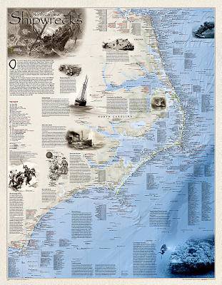
National Geographic Shipwrecks of the Outer Banks Wall Map - Laminated (28 X 36 In)
50,95 €
+ 101 points
Description
Shipwrecks of the Outer Bank illustrates more than 1,550 shipwrecks of the Atlantic Coast from Cape Henry, Virginia to Cape Fear, North Carolina. Each wreck site is symbolized to define the class, type and name of vessel accompanied by the date of sinking. Icons also indicate whether a ship was lost due to conflict or natural causes.
Locations of lifesaving stations and lighthouses, along with navigational beacons are also marked. Bathymetric and coastal features are clearly labeled. Captions and drawings highlight unique historical events.
The map is encapsulated in heavy-duty 1.6 mil laminate which makes the paper much more durable and resistant to the swelling and shrinking caused by changes in humidity. Laminated maps can be framed without the need for glass, so the frames can be much lighter and less expensive.
- Map Scale = 1:447,500
- Sheet Size = 28" x 36"
Spécifications
Parties prenantes
- Auteur(s) :
- Editeur:
Contenu
- Langue:
- Anglais
- Collection :
Caractéristiques
- EAN:
- 9781597755016
- Date de parution :
- 29-06-12
- Format:
- Carte roulée
- Dimensions :
- 89 mm x 944 mm
- Poids :
- 476 g

