- Retrait gratuit dans votre magasin Club
- 7.000.000 titres dans notre catalogue
- Payer en toute sécurité
- Toujours un magasin près de chez vous
- Retrait gratuit dans votre magasin Club
- 7.000.000 titres dans notre catalogue
- Payer en toute sécurité
- Toujours un magasin près de chez vous


Description
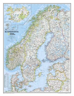
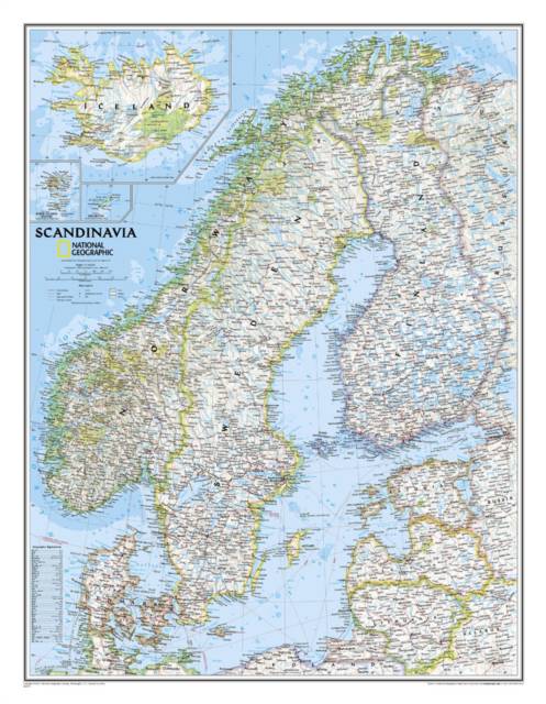
National Geographic's wall map of Scandinavia is one of the largest and most detailed maps of the region. The signature Classic style design uses a bright, easy-to-read color palette. This map features thousands of place names, accurate political boundaries, national parks, and major infrastructure networks such as roads, superhighways, airports, canals, ferry routes, and high-speed and passenger railroads. The region's diverse terrain is detailed through accurate shaded relief, coastal bathymetry, and symbolism for water features and other land forms. Elevations of major peaks and depth soundings are expressed in meters. Inset maps provide detail of Iceland, the Faroe Islands, and Jan Mayen. In addition to Norway, Sweden, and Finland, coverage includes Denmark, Lithuania, Latvia, Estonia, and Kaliningrad Oblast.
The map is packaged in a two inch diameter tube with a label showing a thumbnail of the map with dimensions and other pertinent information.
- Map Scale = 1:2,763,000
- Sheet Size = 23.5" x 30.25"
Spécifications
Parties prenantes
- Auteur(s) :
- Editeur:
Contenu
- Nombre de pages :
- 1
- Langue:
- Anglais
- Collection :
Caractéristiques
- EAN:
- 9780792249856
- Date de parution :
- 23-09-19
- Format:
- Carte roulée
- Dimensions :
- 60 cm x 77 cm
- Poids :
- 54 g