
- Retrait gratuit dans votre magasin Club
- 7.000.000 titres dans notre catalogue
- Payer en toute sécurité
- Toujours un magasin près de chez vous
- Retrait gratuit dans votre magasin Club
- 7.000.000 titres dans notre catalogue
- Payer en toute sécurité
- Toujours un magasin près de chez vous


Description
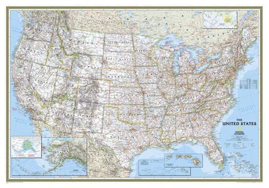
Expertly researched and designed, National Geographic's United States wall map is the standard by which other reference maps of the U.S. are measured.
Product Features:
- Signature Classic styling with bright, easy to read color palette with blue water and colorful state borders
- All 50 states with insets for Hawaiian Islands and Alaska plus inset showing relative size of Alaska
- Clearly defined state and country boundaries, cities, islands, national parks, and physical features
- Thousands of place names carefully and artfully placed to maintain legibility in heavily populated areas
- Background shows mountain ranges and valleys in subtle shaded relief with mountain ranges labeled
- Major water bodies including rivers, lakes, gulfs, bays, straits, and ocean bathymetry
- Transportation routes including interstate highways, major state routes, airports, waterways, canals, and ferries
The map is packaged in a two inch diameter tube with a label showing a thumbnail of the map with dimensions and other pertinent information.
- Map Scale = 1:4,561,000
- Sheet Size = 43.5" x 30.5"
Spécifications
Parties prenantes
- Auteur(s) :
- Editeur:
Contenu
- Nombre de pages :
- 1
- Langue:
- Anglais
- Collection :
Caractéristiques
- EAN:
- 9780792293187
- Date de parution :
- 24-05-22
- Format:
- Carte roulée
- Dimensions :
- 110 cm x 77 cm
- Poids :
- 99 g

