
En raison d'une grêve chez bpost, votre commande pourrait être retardée. Vous avez besoin d’un livre rapidement ? Nos magasins vous accueillent à bras ouverts !
- Retrait gratuit dans votre magasin Club
- 7.000.000 titres dans notre catalogue
- Payer en toute sécurité
- Toujours un magasin près de chez vous
En raison de la grêve chez bpost, votre commande pourrait être retardée. Vous avez besoin d’un livre rapidement ? Nos magasins vous accueillent à bras ouverts !
- Retrait gratuit dans votre magasin Club
- 7.000.0000 titres dans notre catalogue
- Payer en toute sécurité
- Toujours un magasin près de chez vous


Description
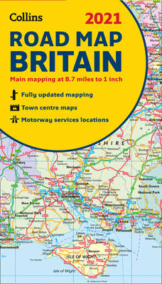
Full colour double-sided map of Great Britain at 8.7 miles to 1 inch (1:550,000), with clear, detailed road network and administrative areas shown in colour.
With its political colouring of counties and unitary authorities it is ideal for business users but it is also perfect for tourists as a route planning map.
Main features
- Fully updated
- Counties and local council areas shown in colour
- Clear, detailed road network
- Town and city names, rivers, railway lines and canals are clearly shown
- 16 city/town centre street plans
- Index to place names
- Mileage chart
- Car ferry routes
- Key in English, French and German
Area of coverage
Double-sided road map covering the whole of Britain. Northern England, Scotland and the Isle of Man are on one side with Southern England and Wales on the other.
Spécifications
Parties prenantes
- Auteur(s) :
- Editeur:
Contenu
- Langue:
- Anglais
- Collection :
Caractéristiques
- EAN:
- 9780008374402
- Date de parution :
- 15-08-20
- Format:
- Carte pliée
- Dimensions :
- 127 mm x 241 mm
- Poids :
- 181 g


Les avis
Nous publions uniquement les avis qui respectent les conditions requises. Consultez nos conditions pour les avis.