
- Retrait gratuit dans votre magasin Club
- 7.000.000 titres dans notre catalogue
- Payer en toute sécurité
- Toujours un magasin près de chez vous
- Retrait gratuit dans votre magasin Club
- 7.000.0000 titres dans notre catalogue
- Payer en toute sécurité
- Toujours un magasin près de chez vous


Description
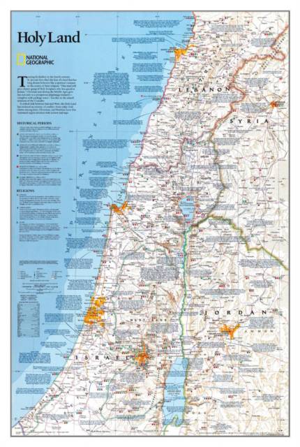
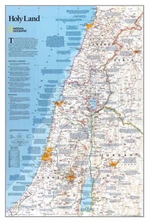
National Geographic's Holy Land wall map provides a fascinating in-depth look at the faiths, peoples, and politics that have shaped this historic region. This detailed political map is overlayed with facts about significant religious sites. Information on Judaism, Christianity, and Islam, as well as historical periods from the Stone and Bronze ages to the Islamic period through 1917 make this as much an educational tool as an attractive work of cartographic art. Cities, bodies of water, geographical features, ruins, Israeli settlements, and more are noted, as are transportation infrastructure such as highways, roads, railroads, canals, and airports. Coverage includes Lebanon, Syria, Jordan, and Israel.
The map is packaged in a two inch diameter tube with a label showing a thumbnail of the map with dimensions and other pertinent information.
- Map Scale = 1:405,500
- Sheet Size = 22.25" x 33"
Spécifications
Parties prenantes
- Auteur(s) :
- Editeur:
Contenu
- Nombre de pages :
- 1
- Langue:
- Anglais
- Collection :
Caractéristiques
- EAN:
- 9780792249719
- Date de parution :
- 01-08-03
- Format:
- Carte roulée
- Dimensions :
- 56 cm x 84 cm
- Poids :
- 51 g

Les avis
Nous publions uniquement les avis qui respectent les conditions requises. Consultez nos conditions pour les avis.