
- Retrait gratuit dans votre magasin Club
- 7.000.000 titres dans notre catalogue
- Payer en toute sécurité
- Toujours un magasin près de chez vous
- Retrait gratuit dans votre magasin Club
- 7.000.0000 titres dans notre catalogue
- Payer en toute sécurité
- Toujours un magasin près de chez vous


Description
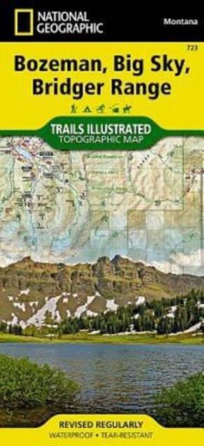
- Waterproof - Tear-Resistant - Topographic Map
The Bridger and Gallatin ranges and their surrounding areas offer year-round recreation opportunities in a landscape of pristine forests, rivers, meadows, and soaring peaks. National Geographic's Trails Illustrated map of Bozeman, Big Sky, and Bridger Range is designed to meet the needs of outdoor enthusiasts by combining valuable information with unmatched detail of this inspiring region. Expertly researched and created in partnership with local land management agencies, this map covers many areas of interest including Gallatin National Forest, Lee Metcalf Wilderness, Hyalite Porcupine Buffalo Horn Wilderness Study Area, Hyalite Reservoir, Beaverhead-Deerlodge National Forest, Gallatin Petrified Forest, and portions of the Yellowstone and Gallatin rivers.
With miles of mapped trails highlighted according to use, this map can guide you off the beaten path and back again in some of the most breathtaking scenery in the region. Trail mileage between intersections, and information on trail use, seasonal trail closures, and trail timesharing will assist you in choosing the path that's right for you. Additional safety tips, agency contact information, and handy Bridger Ridge and Bridger Foothills trail profiles are included as well. Recreation features are clearly marked, including campgrounds, trailheads, interpretive trails, fishing access, boat launches, ski areas, shooting ranges, and points of interest. The map base includes contour lines, shaded relief, and elevations for summits, passes and many lakes.
Every Trails Illustrated map is printed on "Backcountry Tough" waterproof, tear-resistant paper. A full UTM grid is printed on the map to aid with GPS navigation.
Other features found on this map include: Beaverhead National Forest, Blaze Mountain, Bozeman, Bridger Range, Gallatin National Forest, Hyalite Peak, Lee Metcalf Wilderness, Madison Range, Sacagawea Peak.
- Map Scale = 1:70,000
- Sheet Size = 25.5" x 37.75"
- Folded Size = 4.25" x 9.25"
Spécifications
Parties prenantes
- Auteur(s) :
- Editeur:
Contenu
- Nombre de pages :
- 2
- Langue:
- Anglais
- Collection :
Caractéristiques
- EAN:
- 9781566956802
- Date de parution :
- 01-01-17
- Format:
- Carte pliée
- Format numérique:
- Gelamineerd
- Dimensions :
- 10 cm x 19 cm
- Poids :
- 91 g


Les avis
Nous publions uniquement les avis qui respectent les conditions requises. Consultez nos conditions pour les avis.